| |Adventure Sports | |Adventure Travel | |Essential Gear | |Outfitting and Rental |
Permits are needed for overnight camping in the BWCA wilderness area. Permits are issued by designated ranger stations in the area. BWCA ranger stations are located in Ely, Grand Marais, Isabella, Tofte, Cook.
The permits are only good for the entry date and entry point printed on the permit.
Not all entry points are equal, and it pays to choose wisely.
Call Hard Water Sports for entry point advice, 651 302 1774
Questions on Permits?
Entry Points?
Call, and we're here for you.
Contact Hard Water Sports
for Your Next Adventure
651-302-1774
BWCAW Reservation Cente 877-550-6777
Forest Supervisor’s Office
8901 Grand Avenue Place, Duluth, MN 55808
(218) 626-4300
Gunflint Ranger Station
2020 W. Highway 6, Grand Marais, MN 55604
(218) 387-1750
Isabella Work Station
3989 Forest Service Dr. Isabella, MN 55607
(218) 323-7722
Kawishiwi Ranger Station
1393 Hwy 169
Ely, MN 55731
(218) 365-7600
(218) 365-7561 (5/1–9/30)
La Croix Ranger Station
320 N. Hwy 53
Cook, MN 55723
(218) 666-0020
Laurentian Ranger Station
Aurora, MN 55705
(218) 229-8800
Tofte Ranger Station
Tofte, MN 55615
(218) 663-8060
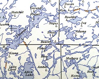
Picking a BWCA Entry Point - What You NEED to Know
Main access roads, from East to West, connecting visitors to the park.
Access from Highway 61 on the North Shore of Lake Superior.
The Arrowhead Trail (County Road 16) Hovland, Minnesota 16 miles to McFarland Lake.
access:Pine Lake #68, John Lake #69, North Fowl Lake #70
The Gunflint Trail (County Road 12) is a two lane paved County Road from Grand Marais, Minnesota and travels 57 wooded and winding miles to Gull Lake.
access: Seagull Lake# 54, Saganaga Lake#55, Missing Link #51, Brant lake #52, Larch Creek #80, Knife Chain #71, Main Chain #72, Falls Chain #73
The Caribou Trail (County Road 4) is a 17 mile two lane road from Hwy 61 just east of Lutsen, Minnesota to The Railroad Grade ( Forest Road 170.)
access:Brule Lake #41
The Sawbill Trail (County Road 2) is a two lane County Road from Hwy 61 in Tofte, Minnesota and north 25 miles to the shore of Sawbill Lake.
access:Sawbill Lake#38, Baker #39Lake
Access from the Ely area
Fernberg Road (Lake County 18) runs east from Ely.
access: Fall Lake #24, Moose Lake #25, Snowbank #27, Lake One #30,
Highway #1 South
access: Farm Lake #31, Kawishiwi River #32, Little Garbo #33
Echo Trail (County Road 116), runs north and west out of Ely and provides the primary access to the lakes of the western Boundary Waters Canoe Area Wilderness (BWCAW). The trail is a 72 miles
access: Moose River #8, Little Indian Sioux River#14, Moose River/Portage River #16,
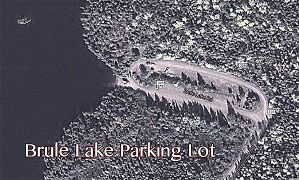
Parking lot on Brule Lake, enough room for 80+ cars,
MN Rafting - Whitewater Canoe Instruction - Canoe and Kayak Rental - BWCA Outfitting
Hard Water Sports - Adventure Outfitting
979 Charles Ave. St Paul MN 55104
651 302 1774
Happy Camping- 5 secrets to a Happy Campsite.
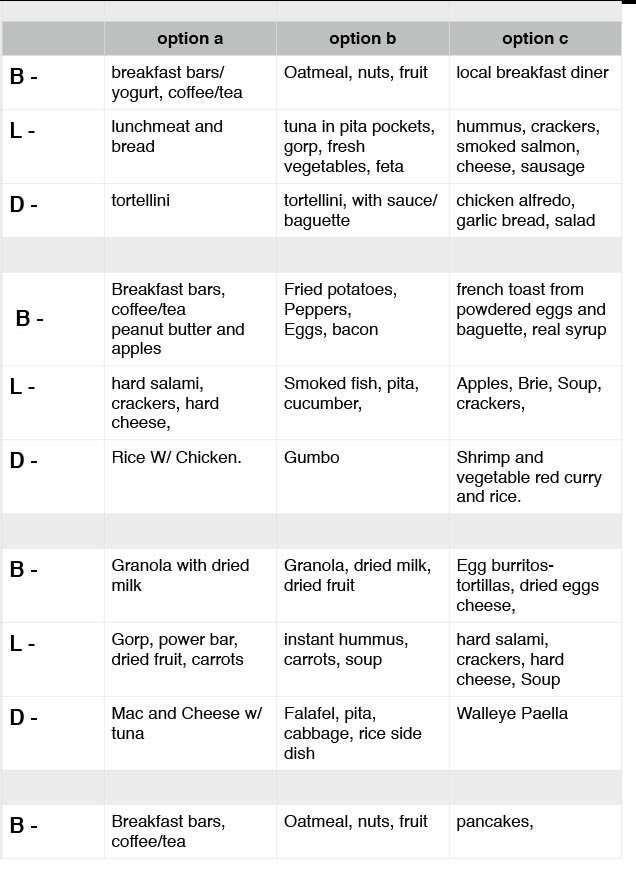
Meal Planning for Your Next BWCA Trip
BWCA Outfitting and Gear Rental
BWCA - Frequently Asked Questions?
Minnesota Whitewater - Yea Sure!